Dinajpur Travel Guide
The district of Uttar Dinajpur
(uttar meaning North) came into existence on 1992-04-01 after the bifurcation
of erstwhile West Dinajpur District. The District lies between latitude
25°11' N to 26°49' N and longitude 87°49' E to 90°00' E occupying an area
of 3142 km2 enclosed by Bangladesh on the east, Bihar on the west, Darjeeling
District and Jalpaiguri District on the north and Malda District and South
Dinajpur District on the south. Uttar Dinajpur is well connected with
the rest of the state through National Highways, State Highways and Railways.
NH-31 and NH-34 pass through the heart of the district.
In Uttar Dinajpur District there are 2 Sub-Divisions Raiganj & Islampur , 110Km apart from each other. District having border length of 227 km (approx) in the east with Bangladesh. There are 4 Municipalities,9 Blocks and 98 Panchayats covering 1516 villages.The total population is nearly 25 Lakh comprising mainly of rural masses.Bengali is the main language but a sizeable portion of Urdu and Hindi speaking people live in Islampur Sub-Division.
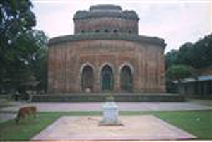
Tourist spots in North Dinajpur Sap-nikla forest, located 22 km from Islampur where visitors can visit the lake and forest for sight seeing. Karnajora Museum and park Burhana Fakirs Mosque Goddess Kalis temple at Baira Malgaon and Kunore Famous for terracotta work Goddess Bhairabis temple at Bindore
In Uttar Dinajpur District there are 2 Sub-Divisions Raiganj & Islampur , 110Km apart from each other. District having border length of 227 km (approx) in the east with Bangladesh. There are 4 Municipalities,9 Blocks and 98 Panchayats covering 1516 villages.The total population is nearly 25 Lakh comprising mainly of rural masses.Bengali is the main language but a sizeable portion of Urdu and Hindi speaking people live in Islampur Sub-Division.
Tourist spots in North Dinajpur Sap-nikla forest, located 22 km from Islampur where visitors can visit the lake and forest for sight seeing. Karnajora Museum and park Burhana Fakirs Mosque Goddess Kalis temple at Baira Malgaon and Kunore Famous for terracotta work Goddess Bhairabis temple at Bindore
 Bangladeshi National Flag.
Dinajpur
|
|
Package List:
|
|
||||||||||||||||||||||||||||||||||||||||||||||